

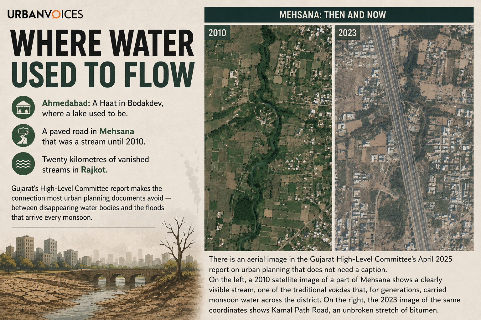
Ahmedabad: A Haat in Bodakdev, where a lake used to be. A paved road in Mehsana that was a stream until 2010. Twenty kilometres of vanished streams in Rajkot. Gujarat’s High-Level Committee report makes the connection most urban planning documents avoid — between disappearing water bodies and the urban floods that arrive every monsoon.
There is an aerial image in the Gujarat High-Level Committee’s April 2025 report on urban planning that does not need a caption. On the left, a 2010 satellite image of a part of Mehsana shows a clearly visible stream, one of the traditional vokdas that, for generations, carried monsoon water across the district. On the right, the 2023 image of the same coordinates shows Kamal Path Road, an unbroken stretch of bitumen.
The stream did not move. It was paved over.
This is not just a Mehsana story. It is a Gujarat story, and the HLC’s chapter on Water-Sensitive Urban Planning is the most blunt section of the entire 268-page document.
The committee — chaired by Shri Keshav Varma and drawing on research from CEPT University, WRI India, and GIZ — assembles case after case, city after city, to make a single argument: most of urban Gujarat is being built on top of the very water systems that used to keep it from flooding.
Ahmedabad: a lake, a TP scheme, and a marketplace
The report opens its case studies in Ahmedabad. It tracks a small lake near Vastrapur Lake — visible in aerial imagery from 2000 — through the city’s Town Planning Schemes. In TPS Bodakdev 1B, the lake’s land was appropriated, its use reclassified, and a proposal for Socially and Economically Weaker Sections (SEWS) housing was introduced over it.
By 2020, even that had changed. A Hatt, or marketplace, now stood where the lake had been. The waterbody had moved through three identities — natural feature, planned housing site, built marketplace — without ever being defended as a waterbody.
Nearby, in Naroda, the report tracks two more cases. Champal Talavadi was actually labelled as a waterbody in its TP scheme — and disappeared anyway. Dhoyu Talavadi was labelled a “neighbourhood centre” and met the same end. Both are now filled and developed as land parcels.
The pattern, the committee concludes, is consistent: statutory plans regularly facilitate the conversion of water bodies into developable land, ultimately leading to their disappearance.
Rajkot: a 27% loss of stream length in a single year
In Rajkot, the city’s natural drainage was, for centuries, a network of small vokdas — streams that local memory still knows by name. CEPT University’s MUI Studio, working with the city in 2023–24, ran a temporal analysis of these streams.
The finding, which the HLC report carries verbatim: a 27 per cent reduction in stream length between 2022 and 2023. Ground-truthing revealed the loss of roughly 20 km of streams in that single window. Some had been built over. Some had been encroached. Some, the report notes carefully, simply disappeared from official maps because no one was looking.
The consequence is the kind of thing residents now experience as routine: more intense rainfall events arriving in a city whose stormwater drainage was never designed for them, falling on built-up land that no longer drains, into a system whose natural arteries have been amputated. Urban flooding in Gujarat, in this telling, is not a freak event. It is the predictable output of a planning regime that treats streams as land-in-waiting.
Navsari: a Development Plan that overlooks its own floodplains
The Navsari case is the most policy-pointed of the lot. The 2039 Development Plan of the Navsari Urban Development Authority (NUDA), the HLC’s analysis shows, overlooks flood-prone areas. Major tributaries, Kaliyawadi Khadi, Jalapore Khadi, and Viraval Khadi, are now obstructed. Unregulated development in floodplain zones has further reduced stormwater drainage capacity.
The older parts of Navsari, the report notes, were developed in harmony with the natural topography and remain comparatively resilient. The newer extensions were not, and are not.
Bhuj: where citizens put a lost lake back on the map
Then there is Bhuj, and here the report turns, briefly, hopeful.
Pragsar Lake in Bhuj, with an original area of more than 54 hectares, was designed approximately 500 years ago as an overflow storage for the larger Hamirsar Lake. By the time the 2001 earthquake struck, its catchment had been neglected for decades, and plots had been sold for residential construction. After the quake, the entire region was filled with debris.
But Bhuj also has citizen groups. Jal Strot Samvardhan Samiti (JSSS), alongside the NGO Arid Communities and Technologies (ACT), has spent years mapping the city’s lost water bodies and pushing local authorities to recognise them on paper. The HLC report carries a side-by-side comparison of Bhuj’s 2011 Development Plan and its 2025 Development Plan, and the difference is visible: lakes that did not exist on the 2011 map, including Umasar Lake, have been re-inserted into the 2025 plan.
The committee’s framing is clear: notifying water bodies through identifying plots and demarcating boundaries is, in its own words, a fundamental aspect of water-sensitive urban planning, and the legal foundation for preventing encroachment.
It is a low bar, and Bhui clearing it is a small win. It also took two decades, an NGO, a citizen samiti, and an earthquake to get there.
The scale of what Ahmedabad and Surat are building over
The HLC chapter draws extensively on WRI India research showing exactly how much new construction has occurred on the ground that used to feed the aquifer.
Ahmedabad
- Built-up cover grew by 46 per cent in the 0–50 km region between 2000 and 2015.
- 47 per cent of new development is sited on high and very high groundwater recharge potential zones.
Surat
- Built-up cover grew by 139 per cent in the 0–50 km region between 2000 and 2015.
- 45 per cent of new development sits on high and very high recharge potential zones.
Both cities are systematically choosing to build on the very ground that is used to refill the aquifer beneath them.
The Lake Redevelopment project that the report is honest about
To its credit, the HLC report does not present Gujarat as helpless. It documents the Lake Redevelopment and Interlinking of Lakes (LRIL) project in Ahmedabad, born out of climate extremes, groundwater depletion, encroachment, and a wave of civic activism and judicial intervention. The project’s groundwater monitoring stations near Vastrapur and Sola lakes have shown level rises of 0.71 m per year and 2.2 m per year, respectively, between 2003 and 2019.
But the same report admits the project’s limits. The overall water spread of the project lakes decreased even where redevelopment happened, because much of the redevelopment was implemented by reclaiming lake land. Lakes like Thaltej and Sola remain under encroachment threat. The committee’s own conclusion: waterfront developments do improve groundwater levels, but isolated efforts cannot compensate for the loss of the broader aquifer system.
What that means, in practice, is that Ahmedabad’s most celebrated lake revival is, on its own terms, a partial success — and the partial-ness is the point. Without statutory protection upstream, every revived lake exists in a city still designed to lose lakes.
What the committee wants Gujarat to do next
The HLC’s recommendations on water are the most far-reaching in the report.
A new statutory framework
The committee proposes that Gujarat introduce, at the state level, an Urban Water Bodies Protection and Conservation Act modelled on a similar 2024 Act in Assam, alongside dedicated Water Bodies and Green Areas Protection and Management Rules (modelled on the Solid Waste Management Rules of the Government of India).
The current arrangement, where waterbody status depends on whether a TP scheme remembers to label a plot blue, is, the report makes clear, structurally inadequate.
A water-first approach to planning
Base maps, plan-making processes, and databases of surface and groundwater systems must be treated as primary inputs to spatial plans at every scale, not as afterthoughts. The committee calls this water-sensitive urban planning and notes that, while the frameworks and concepts already exist globally, no plan in Indian cities has yet demonstrated water sensitivity at scale.
A flood-control overhaul inside GTPUDA
Specific provisions for floodplain zoning, stream conservation, and natural-hazard mapping inside the GTPUDA framework — so that flood prevention becomes a planning function, not a disaster-management afterthought.
Why this report could actually change something
Reports like this one rarely make headlines. They sit on desks, they get cited in academic papers, they shape — slowly — the next round of Development Plans. The HLC’s water chapter has a real chance of being different, for two reasons.
First, it was commissioned by the state government itself, in a year the state had declared the Year of Urban Development. The political distance between recommendation and rule is, in principle, shorter than usual.
Second, the case studies it carries are not from international literature. They are from Vastrapur and Naroda, from Rajkot and Mehsana, from Navsari and Bhuj. They are about places residents recognise, and lakes their parents remember.
If a Haat in Bodakdev can be honest about what is underneath it, perhaps a Development Plan can be too.
Read the full series:
- Part 1: Gujarat Urban Planning 2047 — Does the State Have the Planners?
- Part 3: Urban Redevelopment in Gujarat — Can ‘Creative Redevelopment’ Reshape Cities Without Pushing People Out?
Source: Report of the High-Level Committee on Urban Planning, Urban Development & Urban Housing Department, Government of Gujarat, April 2025. Case study research from CEPT University, WRI India, and GIZ, as cited in the report.




[…] Part 2: Urban Flooding in Gujarat — The Disappearing Lakes Behind the Crisis […]